This section of the site contains our photographs of natural landscapes of the world, including geological formations, relief forms, natural water bodies and vegetation types, as well as some plants and animals, typical to different native zones and geographical regions.
This page contains the list of images of the Laos (South-East Asia)
nature: natural landscapes, vegetation types and some plants and animals.
Clicking on the preview in the list below you will be transferred to the page with the
full sized image
(each photo has a semantic geographical or biological captions, explaining illustrated objects).
Asia
Laos
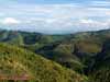
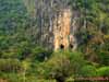
Dai-Laung mountain system (2000 m height).
The humid tropic forests. Indo-China peninsula.
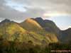
Dai-Laung mountain system (1000 m height).
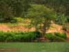
The landscape, changed by human activity and remains of the humid tropic forests.
Indo-China peninsula.
Dai-Laung mountain system (2000 m height).
The humid tropic forests. Indo-China peninsula
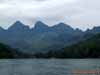
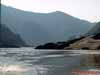
Ou river - the tributary of Mekong, Trannin' plato.
The humid tropic forests. Indo-China peninsula.
Ou river - the tributary of Mekong, Trannin' plato.
The humid tropic forests. Indo-China peninsula.
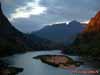
Ou river at the sunset (the tributary of Mekong), Trannin' plato.
The humid tropic forests. Indo-China peninsula.
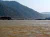
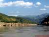
Mekong river middle current, cutting through Dai-Laung mountain system.
The humid tropic forests on the slopes of the mountains.
Mekong river middle current, cutting through crystalline arborization of Dai-Laung
mountain system.
The humid tropic forests on the slopes of the mountains.
Mekong river middle current, cutting through crystalline arborization of Dai-Laung
mountain system.
The humid tropic forests on the slopes of the mountains.
Mekong river middle current, cutting through crystalline arborization of Dai-Laung
mountain system.
The humid tropic forests on the slopes of the mountains.
Mekong river middle current, cutting through crystalline arborization of Dai-Laung
mountain system.
The humid tropic forests on the slopes of the mountains.
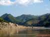
The banks of Mekong river with the exit of crystalline arborization.
The humid tropic forests on the slopes of the mountains.
Mekong river middle current, cutting through crystalline arborization of Dai-Laung
mountain system.
Alluvial sandy sediments of the river on the right.
The humid tropic forests on the slopes of the mountains.
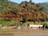
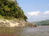
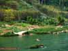
The banks of Ou river, covered with humid tropic forests.
The riverside area is using for agriculture.
The banks of Ou river, covered with humid tropic forests.
The riverside area is using for agriculture.
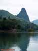
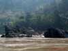
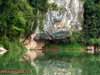
The rocky outcrop on the bank of the Ou river.
Humid tropical forests zone. Indo-China peninsula.
The rocky outcrop on the bank of the Ou river.
Humid tropical forests zone. Indo-China peninsula.
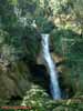
The waterfall on the mountain river in the humid tropical forest.
Luang Prabang, Trannin plateau.
The mountain landscape of Trannin plateau and the valley of Mekong river.
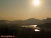
The sunset over Mekong river (middle current).
Laungprabang, Indo-China peninsula.
The sunset over Mekong river (middle current).
Laungprabang, Indo-China peninsula.