 |
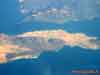
The volcano craters on the Graciosa (La Graciosa) and Lanzarote Islands.
View from the aircraft (10 kilometers). Canary Archipelago |
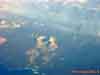 |
The volcano craters on the Lanzarote Island. View from the aircraft (10 kilometers).
Canary Archipelago |
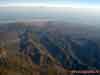 |
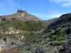
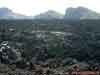
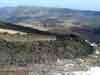
Volcanic massif Pico de las Nieves (Pozo de las Nieves) with the highest point of the
island of Gran Canaria.
View from the aircraft (10 kilometers). Canary Archipelago |
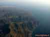 |
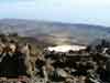
The edge of the volcanic massif Pico de las Nieves on the island of Gran Canaria.
The Atlantic Ocean coast. View from the aircraft (10 kilometers).
Canary Archipelago |
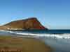 |
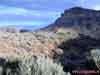
The ancient volcano Montana Roja (171 meters height) and sandy beach Playa de la
Tejita.
South of the Tenerife Island, Canary Archipelago |
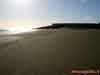 |
Sandy beach Playa de la Tejita after the strong wind.
El Medano outskirts. South of the Tenerife Island, Canary Archipelago |
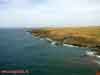 |
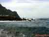
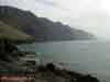
The scarp - wave (undulating) erosion zone of the Atlantic ocean coast.
Teno peninsula (Punta de Teno) — north-west coast of the Tenerife Island, Canary
Archipelago |
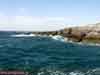 |
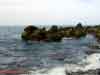
The scarp - wave (undulating) erosion zone of the Atlantic ocean coast.
San Juan — west coast of the Tenerife Island, Canary Archipelago |
 |
The scarp - wave (undulating) erosion zone of the Atlantic ocean coast.
Teno peninsula (Punta de Teno) — north-west coast of the Tenerife Island, Canary
Archipelago |
 |
The scarp - wave (undulating) erosion zone of the Atlantic ocean coast.
Teno peninsula (Punta de Teno) — north-west coast of the Tenerife Island, Canary
Archipelago |
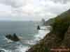 |
The scarp - wave (undulating) erosion zone of the Atlantic ocean coast.
Anaga peninsula — north-east coast of the Tenerife Island, Canary Archipelago |
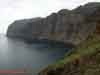 |
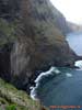
Coastal cliffs - open-cast of the volcanic barranco. Cliff height is about 500 meters.
Los Gigantes area, north-west coast of the Tenerife Island, Canary Archipelago |
 |
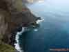
Coastal cliffs - open-cast of the volcanic barranco. Cliff height is about 500 meters.
Los Gigantes area, view from the Teno peninsula.
North-west coast of the Tenerife Island, Canary Archipelago |
 |
Coastal cliffs and surf zone - open-cast of the volcanic rocks.
Road to the Teno peninsula. North-west coast of the Tenerife Island, Canary Archipelago |
 |
Coastal cliffs and surf zone - open-cast of the volcanic rocks.
Road to the Teno peninsula. North-west coast of the Tenerife Island, Canary Archipelago |
|
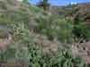 |
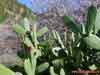
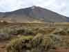
Xerophytic vegetation in the semidesert altitude zone (0-600 meters above sea level)
with Indian Fig Opuntia (Opuntia ficus-indica) and Euphorbia sp. predominance.
Tenerife Island, Canary Archipelago |
 |
Indian Fig Opuntia (Opuntia ficus-indica) and Verode, or Berode (Senecio Kleinia =
Kleinia neriifolia).
Coastal semidesert altitude zone (0-600 meters above sea level).
Tenerife Island, Canary Archipelago |
 |
Euphorbia sp. (probably Euphorbia obtusifolia).
Coastal semidesert altitude zone (0-600 meters above sea level).
Tenerife Island, Canary Archipelago |
 |
Verode, or Berode (Senecio Kleinia = Kleinia neriifolia).
Coastal semidesert altitude zone (0-600 meters above sea level).
Tenerife Island, Canary Archipelago |
 |
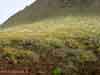
Xerophytic vegetation in the semidesert altitude zone (0-600 meters above sea level)
with Indian Fig Opuntia (Opuntia ficus-indica) and Haworth's aeonium,
or pinwheel (Aeonium haworthii). Tenerife Island, Canary Archipelago |
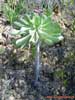 |
Haworth's aeonium, or pinwheel (Aeonium haworthii)
(maybe Aeonium pseudourbicum). Semidesert altitude zone (0-600 meters above sea level).
Tenerife Island, Canary Archipelago |
 |
Young shoot of the Haworth's aeonium, or pinwheel (Aeonium haworthii).
Coastal semidesert altitude zone.
Tenerife Island, Canary Archipelago |
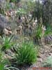 |
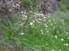
St. Bernard's Lily (Anthericum ramosum).
Coastal semidesert altitude zone.
Tenerife Island, Canary Archipelago |
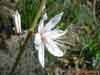 |
The flower (blossom) of the St. Bernard's Lily (Anthericum ramosum).
Coastal semidesert altitude zone.
Tenerife Island, Canary Archipelago |
 |
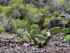
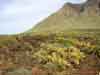
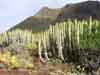
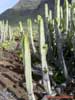
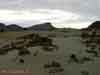
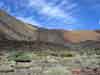
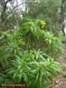
Xerophytic community with Eltham Indian Fig, or Sweet Prickly Pear (Opuntia dillenii)
and Canary Island Spurge, or Hercules Club (Euphorbia canariensis) on the old lava
plateau.
Coastal semidesert altitude zone, Teno peninsula.
North-west coast of the Tenerife Island, Canary Archipelago |
 |
Xerophytic community with Eltham Indian Fig, or Sweet Prickly Pear (Opuntia dillenii)
and Canary Island Spurge, or Hercules Club (Euphorbia canariensis) on the old lava
plateau.
Coastal semidesert altitude zone, Teno peninsula.
North-west coast of the Tenerife Island, Canary Archipelago |
 |
Xerophytic community with Eltham Indian Fig, or Sweet Prickly Pear (Opuntia dillenii)
and Canary Island Spurge, or Hercules Club (Euphorbia canariensis) on the old lava
plateau.
Coastal semidesert altitude zone, Teno peninsula.
North-west coast of the Tenerife Island, Canary Archipelago |
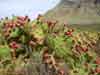 |
Eltham Indian Fig, or Sweet Prickly Pear (Opuntia dillenii) with the fruits.
Coastal semidesert altitude zone, Teno peninsula.
North-west coast of the Tenerife Island, Canary Archipelago |
 |
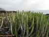
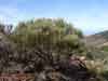
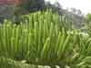
Canary Island Spurge, or Hercules Club (Euphorbia canariensis) on the old lava
plateau.
Coastal semidesert altitude zone, Teno peninsula.
North-west coast of the Tenerife Island, Canary Archipelago |
 |
Canary Island Spurge, or Hercules Club (Euphorbia canariensis) on the old lava
plateau.
Coastal semidesert altitude zone, Teno peninsula.
North-west coast of the Tenerife Island, Canary Archipelago |
 |
Canary Island Spurge, or Hercules Club (Euphorbia canariensis) on the old lava
plateau.
Coastal semidesert altitude zone, Teno peninsula.
North-west coast of the Tenerife Island, Canary Archipelago |
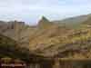 |
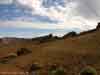
Xerophytic vegetation in the middle altitude zone. 700 meters above sea level.
The Teno peninsula, north-west coast of the Tenerife Island, Canary Archipelago |
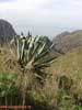 |
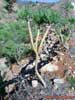
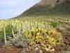
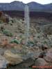
The Century Plant or Maguey (Agave americana) on the dry slope of Masca valley
(barranco).
700 meters above sea level. Teno peninsula, north-west coast of the Tenerife Island,
Canary Archipelago |
 |
The Century Plant or Maguey (Agave americana) with giant inflorescence.
Dry slope of the Masca valley (barranco). 700 meters above sea level.
Teno peninsula, north-west coast of the Tenerife Island, Canary Archipelago |
|
 |
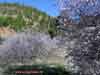
Temperate deciduous forest zone with Almond (Prunus amygdalus = Amygdalus communis)
predominance.
500-800 meters above sea level. Tenerife Island, Canary Archipelago |
 |
Almond (Prunus amygdalus = Amygdalus communis) tree.
Temperate deciduous forest zone (500-800 meters above sea level).
Tenerife Island, Canary Archipelago |
 |
Almond (Prunus amygdalus = Amygdalus communis) and Indian Fig Opuntia (Opuntia
ficus-indica).
Temperate deciduous forest zone (500-800 meters above sea level).
Tenerife Island, Canary Archipelago |
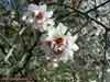 |
Almond (Prunus amygdalus = Amygdalus communis) flower.
Tenerife Island, Canary Archipelago |
|
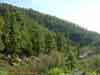 |
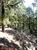
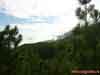
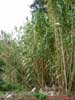
Temperate light coniferous forest zone (600-800 meters above sea level) with Canary
Island pine
(Pinus canariensis) — the endemic of the Canary Islands.
Tenerife Island, Canary Archipelago |
 |
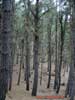
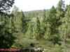
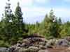
Mountain coniferous forest from Canary Island pine (Pinus canariensis).
Temperate light coniferous forest zone (600-800 meters above sea level).
Tenerife Island, Canary Archipelago |
 |
Mountain coniferous forest from Canary Island pine (Pinus canariensis).
The arborescent spurge (Euphorbia sp.) on the foreground.
Temperate coniferous forest zone (800-1500 meters above sea level).
Tenerife Island, Canary Archipelago |
 |
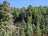
Mountain coniferous forest from Canary Island pine (Pinus canariensis).
Temperate coniferous forest zone (800-1500 meters above sea level).
Tenerife Island, Canary Archipelago |
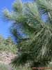 |
Canary Island pine (Pinus canariensis) — the endemic of the Canary Islands.
Temperate coniferous forest zone (800-1500 meters above sea level).
Tenerife Island, Canary Archipelago |
 |
Canary Island pine (Pinus canariensis) — the endemic of the Canary Islands.
Temperate coniferous forest zone (800-1500 meters above sea level).
Tenerife Island, Canary Archipelago |
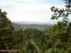 |
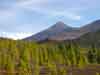
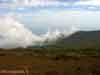
View to the coastal lowland from the coniferous forest zone (1000 meters above sea
level).
The Atlantic ocean coast and Montana Roja volcano are far away.
South of the Tenerife Island, Canary Archipelago |
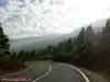 |
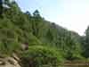
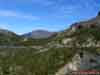
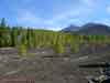
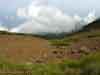
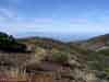
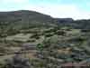
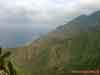
Anaga mountains south-east slopes, covered with the coniferous pine forests.
1000 meters above sea level. South of the Tenerife Island, Canary Archipelago |
 |
Anaga mountains south-east slopes, covered with the coniferous pine forests.
1000 meters above sea level. South of the Tenerife Island, Canary Archipelago |
 |
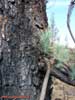
Ripe (mature) mountain coniferous forest from Canary Island pine (Pinus canariensis).
Temperate coniferous forest zone (800-1500 meters above sea level).
Tenerife Island, Canary Archipelago |
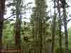 |
Ripe (mature) mountain coniferous forest from Canary Island pine (Pinus canariensis).
The trees are covered with Parmeliaceae lichens (probably Usnea articulata)
Temperate coniferous forest zone (800-1500 meters above sea level).
Tenerife Island, Canary Archipelago |
 |
Ripe (mature) mountain coniferous forest from Canary Island pine (Pinus canariensis).
Temperate coniferous forest zone (800-1500 meters above sea level).
Tenerife Island, Canary Archipelago |
 |
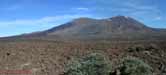
The upper border of the temperate coniferous forest zone (1800 meters above sea
level).
Tenerife Island, Canary Archipelago |
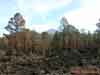
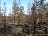 |
Temperate coniferous forest after the forest fire.
Western edge of the Las Canadas caldera (1800 meters above sea level).
Tenerife Island, Canary Archipelago |
 |
Temperate coniferous forest after the forest fire.
Western edge of the Las Canadas caldera (1800 meters above sea level).
Tenerife Island, Canary Archipelago |
 |
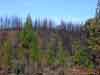
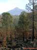
Temperate coniferous forest after the forest fire.
Western edge of the Las Canadas caldera (1800 meters above sea level).
The Teide volcano (Pico del Teide) cone (3718 meters above sea level) is far away.
Tenerife Island, Canary Archipelago |
 |
Temperate coniferous forest after the forest fire.
Western edge of the Las Canadas caldera (1800 meters above sea level).
The Teide volcano (Pico del Teide) cone (3718 meters above sea level) is far away.
Tenerife Island, Canary Archipelago |
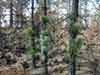 |
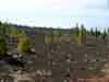
Reforestation of the Canary Island pine (Pinus canariensis) after the fire -
tree trunk shoots (young growth).
Tenerife Island, Canary Archipelago |
 |
Reforestation of the Canary Island pine (Pinus canariensis) after the fire -
tree trunk shoots (young growth).
Tenerife Island, Canary Archipelago |
 |
Altitude vegetation layers in the upper coniferous forest zone.
1800 meters above sea level. The outside (external) slope of the Las Canadas caldera.
Tenerife Island, Canary Archipelago |
 |
Altitude vegetation layers in the upper coniferous forest zone.
1800 meters above sea level. The outside (external) south-west slope of the Las Canadas
caldera.
Tenerife Island, Canary Archipelago |
 |
The oppressed (underdeveloped) pine sparse growth on the edge of Las Canadas caldera.
The volcanic lava and clinker (scoria) of 2000 years-old eruption on the foreground.
1900 meters above sea level. Tenerife Island, Canary Archipelago |
 |
The oppressed (underdeveloped) pine sparse growth on the edge of Las Canadas caldera.
The Gomera Island is far away. 1900 meters above sea level.
Tenerife Island, Canary Archipelago |
|
 |
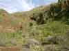
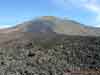
The oppressed (underdeveloped) pine sparse growth
on the volcanic lava and clinker (scoria) fields of 2000 years-old eruption.
Dry xerophytic lava and scoria zone (2000-2500 meters above sea level).
Tenerife Island, Canary Archipelago |
 |
The oppressed (underdeveloped) pine sparse growth
on the volcanic lava and clinker (scoria) fields of 2000 years-old eruption.
Dry xerophytic lava and scoria zone (2000-2500 meters above sea level).
Tenerife Island, Canary Archipelago |
 |
The oppressed (underdeveloped) pine sparse growth on the edge of Las Canadas caldera.
The Teide volcano (Pico del Teide, 3718 m height) cone with well visible barranco is far
away.
Dry xerophytic lava and scoria zone (2000-2500 meters above sea level).
Tenerife Island, Canary Archipelago |
 |
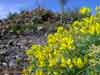
Corazoncillo (Lotus campylocladus, Fabaceae) — the endemic of the Canary Islands.
Dry xerophytic lava and scoria zone (2000-2500 meters above sea level).
Tenerife Island, Canary Archipelago |
 |
Corazoncillo (Lotus campylocladus, Fabaceae)— the endemic of the Canary Islands.
Dry xerophytic lava and scoria zone (2000-2500 meters above sea level).
Tenerife Island, Canary Archipelago |
 |
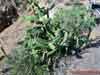
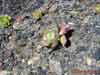
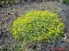
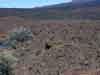
Asteraceae sp.
Dry xerophytic lava and scoria zone (2000-2500 meters above sea level).
Tenerife Island, Canary Archipelago |
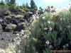 |
Asteraceae sp.
Dry xerophytic lava and scoria zone (2000-2500 meters above sea level).
Tenerife Island, Canary Archipelago |
 |
View to the upper border of the coniferous forest zone.
Dry xerophytic lava and scoria zone (2000-2500 meters above sea level).
Tenerife Island, Canary Archipelago |
 |
Dry xerophytic lava and scoria field (2000-2500 meters above sea level).
The Teide Broom (Spartocytisus supranubius, Genisteae) is on the foreground.
Tenerife Island, Canary Archipelago |
 |
Dry xerophytic lava and scoria field covered with Teide Broom
(Spartocytisus supranubius). 2200 meters above sea level.
Tenerife Island, Canary Archipelago |
 |
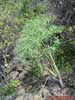
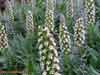
The Teide Broom (Spartocytisus supranubius) shrub.
Dry xerophytic lava and scoria zone (2000-2500 meters above sea level).
Tenerife Island, Canary Archipelago |
 |
The Teide Broom (Spartocytisus supranubius) branches.
Dry xerophytic lava and scoria zone (2000-2500 meters above sea level).
Tenerife Island, Canary Archipelago |
 |
Dry xerophytic lava and scoria field covered with Canary Juniper (Juniperus turbinata
canariensis) and
the Teide Broom (Spartocytisus supranubius). 2200 meters above sea level.
Tenerife Island, Canary Archipelago |
 |
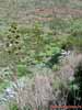
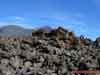
Dry lava and scoria field in the Las Canadas caldera.
Xerophytic vegetation with Balsamiferous Spurge (Euphorbia balsamifera) predominance.
2500 meters above sea level. The Teide volcano (Pico del Teide) cone (3718 meters height)
is far away.
Tenerife Island, Canary Archipelago |
 |
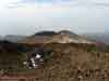
The panorama of the Las Canadas caldera with two volcanic
cones:
the Teide (Pico del Teide, 3718 meters height) and Pico Viejo (3134 meters height).
The lava age is 2000 years (red colour) and 300 years (black colour).
Shooting point is at 2500 meters above sea level.
Tenerife Island, Canary Archipelago |
|
 |
The side crater of the Pico Viejo volcano (3134 meters height).
Black lava and scoria on the foreground is 300 years old (from the 1709 eruption).
Shooting point is at 2500 meters above sea level.
Tenerife Island, Canary Archipelago |
 |
Lava and scoria sediments on the foot of Pico Viejo volcano (3134 meters height).
The lava age is 2000 years (red colour) and 300 years (black colour).
Shooting point is at 2500 meters above sea level.
Tenerife Island, Canary Archipelago |
 |
Volcanic lava and scoria sediments from the 1709 eruption.
The foot of Pico Viejo volcano.
Tenerife Island, Canary Archipelago |
 |
Volcanic lava and scoria sediments from the 1709 eruption.
covered with Teide Broom (Spartocytisus supranubius).
Shooting point is at the foot of Pico Viejo volcano (2400 meters above sea level).
Tenerife Island, Canary Archipelago |
 |
Volcanic lava and scoria field from 1709 eruption.
Las Canadas caldera at the foot of Pico Viejo volcano.
2400 meters above sea level, Tenerife Island, Canary Archipelago |
 |
Volcanic lava and scoria field from 2000 year-old eruption.
Las Canadas caldera at the foot of the Teide volcano.
The Garcia Rock (Roques de Garcia) - the result of weathering (atmogenic erosion) far
away.
2500 meters above sea level, Tenerife Island, Canary Archipelago |
 |
The Las Canadas caldera edge near the Garcia Rock (Roques de Garcia).
Xerophytic vegetation with the Teide Broom (Spartocytisus supranubius) predominance
on the 2000 year-old volcanic lava and scoria field.
2500 meters above sea level, Tenerife Island, Canary Archipelago |
 |
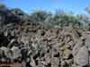
Volcanic lava and scoria field from 2000 year-old eruption on the bottom of the
Las Canadas caldera. Dried (old) inflorescence of the Tower of Jewels (Echium wildpretii)
— the endemic of the Canary Islands.
2500 meters above sea level, Tenerife Island, Canary Archipelago |
 |
Volcanic lava and scoria field from 2000 year-old eruption on the bottom of the
Las Canadas caldera. 2500 meters above sea level, Tenerife Island, Canary Archipelago |
 |
Volcanic lava and scoria field from 2000 year-old eruption on the bottom of the
Las Canadas caldera. 2500 meters above sea level, Tenerife Island, Canary Archipelago |
 |
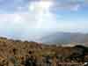
The volcanic lava flows on the Teide volcano slope.
Xerophytic vegetation with Balsamiferous Spurge (Euphorbia balsamifera) and
Teide Broom (Spartocytisus supranubius) predominance.
2500 meters above sea level, Tenerife Island, Canary Archipelago |
 |
The volcanic lava flows (300 years age) descending through the Teide volcano slope.
You can also see the edge of Las Canadas caldera - the crater of the ancient proto-volcano
26 kilometers in diameter. Shooting point is at 3300 meters above sea level.
Tenerife Island, Canary Archipelago |
 |
View to the Las Canadas caldera from the Teide volcano top.
The Las Canadas caldera - the crater of the ancient proto-volcano
26 kilometers in diameter.
Shooting point is at 3550 meters above sea level. Tenerife Island, Canary Archipelago |
 |
The top crater of the Pico Viejo volcano (3134 meters above sea level).
View from the Teide volcano top.
Shooting point is at 3300 meters above sea level. Tenerife Island, Canary Archipelago |
 |
View to the north-east part of the Tenerife Island, north coast, Orotava valley
(Valle de la Orotava) and Puerto de la Cruz city and resort from the Teide volcano top.
Shooting point is at 3600 meters above sea level. Tenerife Island, Canary Archipelago |
 |
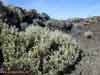
The panorama of the Teide volcano from the Las Canadas
caldera north-east plateau.
The alpine xerophytic vegetation zone with Balsamiferous Spurge (Euphorbia balsamifera),
Teide Broom (Spartocytisus supranubius) and herb-grass predominance.
Tenerife Island, Canary Archipelago |
|
|
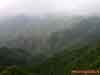 |
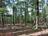
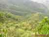
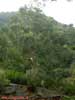
Evergreen deciduous forests on the south-east slope of Anaga peninsula mountains.
Middle height altitude zone (700-1200 meters above sea level).
Tenerife Island northern coast, Canary Archipelago |
 |
Evergreen deciduous forests on the south-east slope of Anaga peninsula mountains.
Middle height altitude zone (700-1200 meters above sea level).
Tenerife Island northern coast, Canary Archipelago |
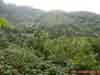 |
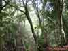
Evergreen deciduous forest on the south-east slope of Anaga peninsula mountains.
Middle height altitude zone (700-1200 meters above sea level).
Tenerife Island northern coast, Canary Archipelago |
 |
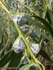
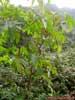
Evergreen deciduous forest with River Red Gum (Eucalyptus camaldulensis)
(maybe Forest Red Gum - Eucalyptus tereticornis) predominance on the south-east
slope of Anaga peninsula mountains.
Middle height altitude zone (700-1200 meters above sea level).
Tenerife Island northern coast, Canary Archipelago |
 |
River Red Gum (Eucalyptus camaldulensis) (maybe Forest Red Gum - Eucalyptus
tereticornis).
Evergreen deciduous forest zone (700-1200 meters above sea level).
Anaga peninsula, Tenerife Island northern coast, Canary Archipelago |
 |
The flower bud of the River Red Gum (Eucalyptus camaldulensis)
(maybe Forest Red Gum - Eucalyptus tereticornis).
Tenerife Island northern coast, Canary Archipelago |
 |
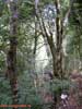
Evergreen deciduous (laurel) forest with Laurel Tree (Laurus novocanariensis)
predominance
on the south-east slope of Anaga peninsula mountains.
Middle height altitude zone (700-1200 meters above sea level).
Anaga peninsula, Tenerife Island northern coast, Canary Archipelago |
 |
Evergreen deciduous (laurel) forest with Laurel Tree (Laurus novocanariensis)
predominance
on the south-east slope of Anaga peninsula mountains.
Middle height altitude zone (700-1200 meters above sea level).
Anaga peninsula, Tenerife Island northern coast, Canary Archipelago |
 |
Laurel (Laurus novocanariensis) young tree.
Evergreen deciduous forest zone (700-1200 meters above sea level).
Anaga peninsula, Tenerife Island northern coast, Canary Archipelago |
 |
The Castor Bean, or Palma Christi (Ricinus communis) (Euphorbiaceae family)
on the evergreen deciduous forest edge.
Middle height altitude zone (700-1200 meters above sea level).
Anaga peninsula, Tenerife Island northern coast, Canary Archipelago |
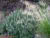
 |
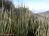
Common Reed (Phragmites communis = Phragmites australis) (Grass Family)
on the evergreen deciduous forest edge.
Middle height altitude zone (700-1200 meters above sea level).
Anaga peninsula, Tenerife Island northern coast, Canary Archipelago |
 |
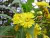
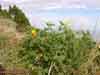
Sow Thistle (Sonchus congestus)(Asteraceae Family) on the evergreen deciduous forest
edge.
Middle height altitude zone (700-1200 meters above sea level).
Anaga peninsula, Tenerife Island northern coast, Canary Archipelago |
 |
Sow Thistle (Sonchus congestus)(Asteraceae Family) flowers.
Middle height altitude zone (700-1200 meters above sea level).
Anaga peninsula, Tenerife Island northern coast, Canary Archipelago |
 |
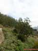
Humid rainwater slopes of the Anaga peninsula northern coast.
Tenerife Island northern coast, Canary Archipelago |
 |
The California Poppy (Eschscholzia californica) (Papaveraceae Family).
Humid rainwater slopes of the Anaga peninsula northern coast.
Tenerife Island northern coast, Canary Archipelago |
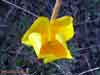 |
The California Poppy (Eschscholzia californica) flower.
Humid rainwater slopes of the Anaga peninsula northern coast.
Tenerife Island northern coast, Canary Archipelago |
 |
The Rosy Garlic (Allium roseum) (Alliaceae Family) herbage.
700 meters above sea level in the Masca valley (barranco) on the Teno peninsula.
North-west coast of the Tenerife Island, Canary Archipelago |
 |
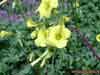
The Tower of Jewels (Echium virescens) — the endemic of the Canary Islands
(Boraginaceae Family).
700 meters above sea level in the Masca valley (barranco) on the Teno peninsula.
North-west coast of the Tenerife Island, Canary Archipelago |
 |
The Tower of Jewels (Echium virescens) flowers — the endemic of the Canary Islands
(Boraginaceae Family).
700 meters above sea level in the Masca valley (barranco) on the Teno peninsula.
North-west coast of the Tenerife Island, Canary Archipelago |
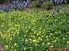 |
Bermuda buttercup, or African wood-sorrel, or Bermuda sorrel (Oxalis pes-caprae)
(Oxalidaceae Family) herbage on the evergreen deciduous forest edge.
Middle height altitude zone (700-1200 meters above sea level).
Anaga peninsula, Tenerife Island northern coast, Canary Archipelago |
 |
Bermuda buttercup, or African wood-sorrel, or Bermuda sorrel (Oxalis pes-caprae)
(Oxalidaceae Family) on the evergreen deciduous forest edge.
Middle height altitude zone (700-1200 meters above sea level).
Anaga peninsula, Tenerife Island northern coast, Canary Archipelago |
 |
Crystal Ice Plant, or Kristallina tar-ramel ((Mesembryanthemum crystallinum)
(Aizoaceae Family, Caryophyllales Order) herbage.
Middle height altitude zone (700-1200 meters above sea level).
Anaga peninsula, Tenerife Island northern coast, Canary Archipelago |
 |
Garden Nasturtium, or Indian Cress, or Monks Cress (Tropaeolum majus)
(Tropaeolaceae Family) wild herbage on the Atlantic Ocean coast.
Playa de Benijo, Anaga peninsula, Tenerife Island northern coast, Canary Archipelago |
 |
Garden Nasturtium, or Indian Cress, or Monks Cress (Tropaeolum majus)
(Tropaeolaceae Family) on the Atlantic Ocean coast.
Playa de Benijo, Anaga peninsula, Tenerife Island northern coast, Canary Archipelago |
|
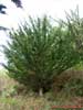 |
Cypress tree (Cupressus sp., Cupressaceae Family) on the village suburb.
Tenerife Island, Canary Archipelago |
 |
Cypress tree (Cupressus sp., Cupressaceae Family) branches and cones.
Tenerife Island, Canary Archipelago |
 |
Norfolk Island Pines (Araucaria heterophylla), cultivated near the road in the
village.
Tenerife Island, Canary Archipelago |
 |
The Norfolk Island Pines (Araucaria heterophylla) branches (shoots).
Tenerife Island, Canary Archipelago |
 |
The Norfolk Island Pines (Araucaria heterophylla) branches (shoots).
Tenerife Island, Canary Archipelago |
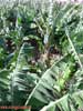 |
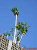
Cultivated Banana (Musa Genus) plantations.
Tenerife Island, Canary Archipelago |
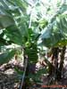 |
Cultivated Banana (Musa Genus) plant (grass).
Tenerife Island, Canary Archipelago |
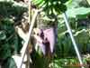 |
Cultivated Banana (Musa Genus) flower (bud).
Tenerife Island, Canary Archipelago |
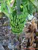 |
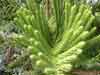
Cultivated Banana (Musa Genus) collective fruit (cluster, bunch).
Tenerife Island, Canary Archipelago |
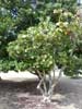
 |
Papaya, or papaw, or fruta bomba, or lechosa, or melon tree (Carica papaya)
(Caricaceae Family) with fruits.
Tenerife Island, Canary Archipelago |
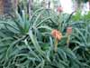 |
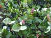
Flowering Socoirine Aloes (Aloe socotrina) (Asphodelaceae Family).
Tenerife Island, Canary Archipelago |
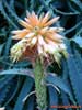 |
Socoirine Aloes (Aloe socotrina) (Asphodelaceae Family) flower.
Tenerife Island, Canary Archipelago |
 |
Cultivated spurge (Euphorbia sp.) (Euphorbiaceae Family).
Tenerife Island, Canary Archipelago |
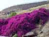 |
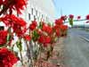
The Bougainvillea herbage on the mountain slope.
Tenerife Island, Canary Archipelago |
 |
The Sea Grape (Coccoloba uvifera) (Polygonaceae, or Buckwheat Family)
on the edge of a sandy beach.
Tenerife Island, Canary Archipelago |
 |
The Sea Grape (Coccoloba uvifera) (Polygonaceae, or Buckwheat Family) with the fruits.
Tenerife Island, Canary Archipelago |
 |
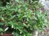
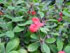
The Poinsettia (Euphorbia pulcherrima) (Euphorbiaceae Family).
Tenerife Island, Canary Archipelago |
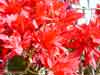 |
The Poinsettia (Euphorbia pulcherrima) (Euphorbiaceae Family).
Tenerife Island, Canary Archipelago |


