This section of the site contains our photographs of natural landscapes of the world, including geological formations, relief forms, natural water bodies and vegetation types, as well as some plants and animals, typical to different native zones and geographical regions.
This page contains the list of images of the Kuril Islands: Kunashir,
Atlasov and Paramushir (Russian Far East) nature: volcanoes, mountains and natural
landscapes.
Clicking on the preview in the list below you will be transferred to the page with the
full sized image
(each photo has a semantic geographical or biological captions, explaining illustrated objects).
Russia - Asia
Kuril Islands (Kuril archipelago), Pacific
ocean
(Kunashir Island, Atlasov Island and Paramushir Island)
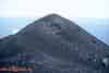
Top of the Alaid volcano cone. Height - 2339 meters above sea level.
Atlasov Island
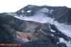
Ancient caldera - the basement of the old Alaid volcano and a
new Alaid volcano slope covered by scoria sediments (pyroclastic material).
Altitude - 1050 meters above sea level. Atlasov Island
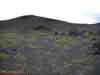
One of the 33 side (collateral) craters of Alaid volcano.
Atlasov Island
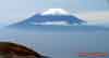
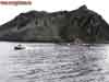
Alaid volcano on the Atlasov Island (height - 2339 meters above sea level).
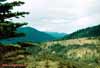
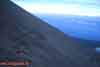
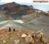
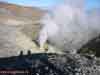
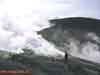
View from the Ebeko volcano top on the Paramushir Island
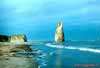
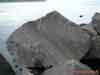
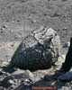
Lava block from the Taketomi volcano eruption. Atlasov Island
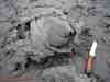
Volcanic bomb from the Taketomi volcano eruption. Atlasov Island
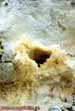
Volcanic scoria crater plug (stopper). Taketomi volcano at Atlasov Island
Taketomi volcano - it is a side (collateral) crater of the Alaid volcano.
The cone is composed from the porous eruption sediments, coherent with lava
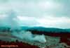
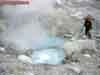
Steam-to-gas streams spurted from the fumarole field "Iyulskoye" (July).
Ebeko volcano, Paramushir Island
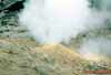
Volcanic boiling copper. North-East fumarole field of the Ebeko volcano.
Paramushir Island
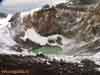
Active funnel of the Ebeko volcano Northern crater
with hyeracid thermal lake. Paramushir Island
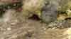
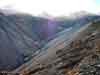
One of the thermal stream "Lagerniy" (Camping) sources on the eastern slope
of the Ebeko volcano. Paramushir Island
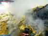
Fumarole sulfur of the Ebeko volcano. Paramushir Island
Volcanic bomb of the "crust of bread" type in the Ebeko volcano Northetn
crater.
Paramushir Island
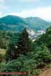
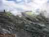
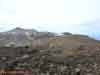
View to the Middle and Northern craters of the Ebeko volcano from its top.
Paramushir Island
Fumarole field "Iyulskoye" (July). Gas temperature is 493 °С.
Paramushir Island
Fissure (crack) in the piroclastic sediments on the external slope of the
Ebeko volcano crater (3 meters deep). Paramushir Island
Fumarole "Uragannaya" (Hurricane). The speed of gas outflow is more than
30 meters per second. Paramushir Island
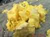
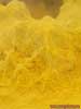
Plastic sulfur (hair type) produced by the "Pauk" (Spider) fumarole.
Paramushir Island
Plastic sulfur (hair, of spider net type) produced by the "Pauk" (Spider)
fumarole.
Paramushir Island
Strong steam-to-gas streams spurted from the fumarole field "Iyulskoye"
(July),
arised in 2005 on the external slope of the Ebeko volcano Northern crater.
Paramushir Island
Fumarole fields on the Ebeko volcano eastern slope.
Paramushir Island
"Lagerniy" (Camping) stream, collecting a few thermal streams flowing
from the eastern slope of Ebeko volcano. Paramushir Island